You’re a racist unless you say these are just poor people looking for jobs. You’re a racist if you don’t invite them into your home with your children and pets and hire them in your company.
10/29/18, “Migrants clash with police at Guatemala-Mexico border,” Reuters

Above, 10/28/18, “Bienvenidos a Mexico:” “Migrants try to climb the Mexican border gate on the bridge between Guatemala and Mexico in Tecun Uman. REUTERS/Carlos Garcia Rawlins”

Above, 10/28/18, “A group of men, part of a caravan of thousands of migrants from Central America en route to the U.S, pull down the border gate in Tecun Uman, Guatemala, October 28, 2018. REUTERS/Carlos Garcia Rawlins”
.........

Above, 10/28/18, “Migrants throw stones at Mexican Police in Tecun Uman. REUTERS/Carlos Garcia Rawlins”

Above, 10/28/18, “Men push the border gate as they try to cross into Mexico in Tecun Uman. REUTERS/Carlos Garcia Rawlins”
........

Above, 10/28/18, “Migrants throw stones at riot police as they try to break through the border gate to cross into Mexico in Tecun Uman. REUTERS/Carlos Garcia Rawlins”

Above, 10/28/18, “Men throw stones at a Mexican Police helicopter after they pull down the border gate in Tecun Uman. REUTERS/Carlos Garcia Rawlins”
..........

.......
Above, 10/28/18, “Migrants try to climb the Mexican border gate in Tecun Uman. REUTERS/Carlos Garcia Rawlins”
.......
Above, 10/28/18, “Migrants try to climb the Mexican border gate in Tecun Uman. REUTERS/Carlos Garcia Rawlins”
.......


Above, 10/28/18, “Migrants throw stones at Mexican Police in Tecun Uman. REUTERS/Carlos Garcia Rawlins”
......

Above, 10/28/18, “A man throws a stone at Mexican Police in Tecun Uman. REUTERS/Carlos Garcia Rawlins”
Below: Earlier caravan en route 10/21/18:

Above, Oct. 21, 2018: “A migrant caravan, which has grown into the thousands, walks into the interior of Mexico after crossing the Guatemalan border on Oct. 21, 2018, near Ciudad Hidalgo, Mexico. (John Moore / Getty Images)“
…………………………
Added: US government has lost the basis for collecting taxes. The US is no longer a country:
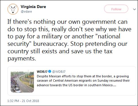
10/21/18, “If there’s nothing our own government can do to stop this, really don’t see why we have to pay for a military or another “national security” bureaucracy. Stop pretending our country still exists and save us the tax payments.” Virginia Dare twitter via Ann Coulter twitter
………………….
Added: Entire US political class would be thrilled if Central American population replaced US population. Just before 2006 midterms–Oct. 26, 2006–Republicans passed a fake border fence act which they cancelled in 2007-Politifact, 5/16/2011. The Oct. 26, 2006 Secure Fence Act of 2006, was quietly altered [by Republicans] in a significant way the following year (2007)….The law was amended to read, “nothing in this paragraph shall require the Secretary of Homeland Security to install fencing.”…
——————
Politifact on “border fence:”
5/16/2011, “Obama says the border fence is ‘now basically complete’,“ PolitiFact, Robert Farley
 “Sections of the fence on the Mexico border, like this one near San Miguel, Ariz., are designed primarily to stop vehicles.” Politifact photo
“In his speech in El Paso on immigration reform on May 10, 2011, President Obama declared that the fence along the border with Mexico is “now basically complete."
 Still, he predicted that many Republican opponents won’t be satisfied.
“We have gone above and beyond what was requested by the very Republicans who said they supported broader reform as long as we got serious about enforcement,” Obama said. “All the stuff they asked for, we’ve done. But even though we’ve answered these concerns, I’ve got to say I suspect there are still going to be some who are trying to move the goal posts on us one more time.”
“They’ll want want a higher fence,” Obama said. “Maybe they’ll need a moat. Maybe they want alligators in the moat. They’ll never be satisfied. And I understand that. That’s politics.”
Fencing along the U.S.-Mexico border has long been a thorny political issue, so with Obama declaring mission accomplished, we decided to check it out….
DHS reports that there is now fencing for 649 of the 652 miles described in the Secure Fence Act of 2006. But the vast majority of the requirement was met with vehicle barriers and single-layer pedestrian fence. The original act specifically called for double-layer fencing, and only 36.3 miles of double-layered fencing currently exist. However, the act was later amended to allow Border Security the discretion to determine which type of fencing was appropriate for different areas.…
You need to go back to the Secure Fence Act of 2006, which was passed by a Republican Congress and signed by President George W. Bush [on Oct. 26, 2006]. It authorized the construction of hundreds of miles of additional fencing along the border with Mexico. The act specified “at least two layers of reinforced fencing.”
But the law was quietly altered in a significant way the following year….
Sen. Kay Bailey Hutchison, R-Texas, proposed an amendment to give DHS the discretion to decide what type of fence was appropriate in different areas. The law was amended to read, “nothing in this paragraph shall require the Secretary of Homeland Security to install fencing, physical barriers, roads, lighting, cameras, and sensors in a particular location along an international border of the United States, if the Secretary determines that the use or placement of such resources is not the most appropriate means to achieve and maintain operational control over the international border at such location.”
In other words, Border Patrol would have the leeway to decide which type of fencing was appropriate in various regions. The amendment was included in a federal budget bill in late 2007 despite being condemned by legislators such as Reps. Peter King, R-N.Y., and Duncan Hunter, R-Calif., who argued the amendment effectively killed the border fence promised in the 2006 bill.
At the time, Hutchison told the San Antonio Express-News, “Border patrol agents reported that coyotes and drug-runners were altering their routes as fencing was deployed, so the amendment gives our agents discretion to locate the fence where necessary to achieve operational control of our border.”
DHS reports there are currently 36.3 miles of double-layered fencing, the kind with enough gap that you can drive a vehicle between the layers. But the majority of the fencing erected has been vehicle barriers, which are designed to stop vehicles rather than people (see here), and single-layer pedestrian fencing (see here). [Links go to generic Border Patrol site with pictures, not to specific picture of fences].
The design specifications vary depending on geography and climate characteristics, but according to the Customs and Border Patrol website, it includes “post on rail” steel set in concrete; steel picket-style fence set in concrete; vehicle bollards similar to those found around federal buildings; “Normandy” vehicle fence consisting of steel beams; and concrete jersey walls with steel mesh….
“They are interpreting the requirements of the Secure Fence Act in a way that is clearly contrary to what Congress intended,” said Mark Krikorian, executive director of the Center for Immigration Studies, which favors tougher enforcement against illegal immigration.
There may be a role for the vehicle barriers, but “your grandmother could hop over them,” he said, and “that’s not what Congress thought it was voting for.”…
A Government Accountability Office report on border security, issued in February 2011…acknowledges progress on the fences…but “DHS reports that the southwest border continues to be vulnerable to cross-border illegal activity, including the smuggling of humans and illegal narcotics.”…
It is estimated that for every person caught (Border Patrol reported apprehending over 445,000 illegal entrants in 2010) two more get by, [retired president of National Border Patrol Concil T.J.] Bonner said. “To me, that doesn’t seem like border security.”…
So Obama can make a case that the vehicle barriers and single-layer pedestrian fences meet the amended letter of the law. But we also think Obama misleads, particularly when he mocks Republican opponents, saying that even though the fence has been built, “They’ll want want a higher fence. Maybe they’ll need a moat. Maybe they want alligators in the moat.” The Border Patrol has not gone “above and beyond” what Republicans requested, as Obama claimed. What they originally requested was a double-layer fence, and they didn’t get much of it. And so we rate Obama’s statement Barely True. [Changed to “Mostly False” per Editor’s note below]
.
“Editor’s note: This statement was rated Barely True when it was published. On July 27, 2011, we changed the name for the rating to Mostly False.”
…………….
Added:
2006 Fence Act didn’t require fences, merely “authorized” them:
10/26/2006, “Fact Sheet: The Secure Fence Act of 2006″
“Authorizes the construction of hundreds of miles of additional fencing along our Southern border"…
But...
The Fence Act also authorized “adding thousands of new beds” at detention facilities.
………………….
7/11/2007, “Border Fence Construction Not Moving Fast Enough for Rep. Hunter,“ NY Times, by Eleanor Stables, Congressional Quarterly
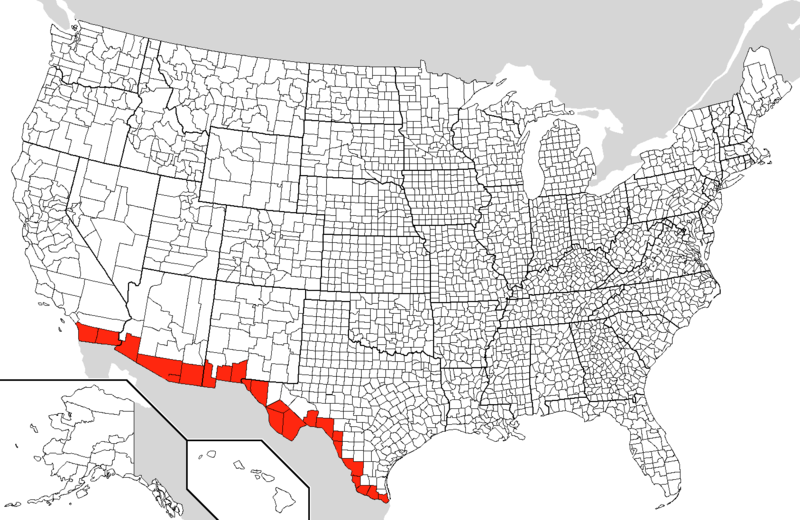
“The Secure Fence Act (PL 109-367), passed just before the 2006 midterm elections, authorizes 700 miles of fencing along the Mexican border. Then-House Homeland Security Chairman Peter T. King, R-N.Y., sponsored the bill, and Hunter was an original cosponsor and author of its fencing provisions. The bill passed after a [so-called] comprehensive immigration overhaul failed last session; the defeat of the Senate immigration bill (S 1639) late last month means a [so-called] comprehensive immigration overhaul is also unlikely this session.
The Secure Fence Act says “the Secretary of Homeland Security shall provide for least 2 layers of reinforced fencing, the installation of additional physical barriers, roads, lighting, cameras and sensors” at five specific stretches of border totaling approximately 700 miles.”...
………………………….
Added: US government has ceded at least a quarter of the 2000 mile southern border land to drug cartels. Easiest way to illegally cross US border is Texas Big Bend area, few patrols. What’s to stop them, says border agent-LA Times, 12/16/2017
12/16/2017, “Could the Big Bend in Texas be the border’s weakest link? Smuggling of drugs and migrants is on the rise,” LA Times, Molly Hennessy-Fiske
Added: US government has ceded at least a quarter of the 2000 mile southern border land to drug cartels. Easiest way to illegally cross US border is Texas Big Bend area, few patrols. What’s to stop them, says border agent-LA Times, 12/16/2017
12/16/2017, “Could the Big Bend in Texas be the border’s weakest link? Smuggling of drugs and migrants is on the rise,” LA Times, Molly Hennessy-Fiske

“Just yards from the Rio Grande, Agent Lee Smith pointed to footprints and scraps of carpet. Smugglers tie carpet to their shoes in hopes of covering their tracks,
he said. Smith followed the rough trail through thick brush, his fellow
agent close behind, wearing a bulletproof vest and carrying a long gun. They saw no one. But the agents sensed smugglers watching, waiting.
“They come right across. What’s here to stop them?” Smith said.
Sometimes smuggler scouts cross on horseback: The muddy banks are pocked with human and horse tracks. The river here, about 60 miles east of El Paso, is just a few yards wide, one of the reasons Border Patrol agents in Texas’ Big Bend region have seen troubling increases in smuggling, attacks on agents and migrant deaths in recent years.
“There’s hundreds of these crossings just in our area of operation,” Smith said. “The drug cartels, they own this part of the land. We have conceded large swaths of the border. There are areas where there are not agents for days.”
He called the vast Big Bend “the absolute weakest link on the southern border.”
The natural barriers beyond the river that made the landscape a stunning backdrop for “No Country for Old Men,” “There Will Be Blood” and “Giant” were also supposed to protect it. Or at least that was long the assumption of U.S. officials. There’s the river. There are mountains–the snow-covered Chinati, Chisos and Davis ranges….
But smuggling routes shift according to the dictates of criminal organizations, often in response to border enforcement. In the late 1990s, border traffic moved from Southern California to remote desert stretches of Arizona; by 2013, it moved east again to Texas’ Rio Grande Valley, the epicenter of migration and enforcement ever since. But now new routes are opening up to the west, in Big Bend.
“As things in the Rio Grande Valley get tougher to cross, they’re looking for other places, and this is a spot that over the past few years has become established for smuggling,” said Border Patrol Agent Rush Carter, a spokesman for the agency in Big Bend.
Just as migrants once tried to cross the Arizona desert unprepared, Central Americans are arriving in Big Bend without cold weather gear, abandoned to the elements by smugglers. Migrants tell agents that smugglers advertise the area as an easy crossing, the least patrolled stretch of border.
U.S. Customs and Border Protection divides the southern border into nine sectors. Big Bend is the largest: 135,000 square miles, 510 miles of river, a quarter of the entire southern border.
The sector stretches north to include 118 counties in Texas and all of Oklahoma. Yet it has the smallest staff of any southern border sector, about 500 agents assigned to a dozen stations and several highway checkpoints including one in Sierra Blanca, notorious for large drug busts. That’s fewer agents than have been assigned to a single station in the Tucson sector, Smith said.
President Trump has promised to add 5,000 Border Patrol agents, potentially doubling Big Bend staffing, but with high turnover, agents said that they would still be spread thin.
With such a small staff, agents usually patrol alone, with hand-me-down technology from other areas, including radios so spotty agents have erected makeshift cell towers in the brush to boost reception. Sometimes they just yell.
They don’t have observation towers along the border as in the Rio Grande Valley, and their single aerostat blimp hovering overhead, unlike those used in the Valley, is not equipped with infrared technology, Smith said.
“You know what it [the blimp] helps?” Smith said. “Migrants. They use it as a guide: Go that direction.”
The only time they received drones, agents complained, was when the devices were sent west from southeast Texas for safekeeping before Hurricane Harvey hit in August.
Since the summer [2017], Big Bend saw the biggest increase in unaccompanied youth caught on the border, mostly Central Americans:
278 since the federal fiscal year that began in October, up 74% from last year. By contrast, the number of youths caught in the Rio Grande area dropped 64% during the same period.
At the same time, Big Bend saw drug seizures drop, Smith and other agents said. That’s because smugglers use the migrants as decoys, they said, and abandon dozens at a time to overwhelm agents, before sending drug mules with 50-pound backpacks of marijuana in their wake.
Big Bend agents caught 6,000 people last fiscal year, which ended in September. During the next two months, they caught 1,646 people, putting them on pace to far exceed last year’s total.
Big Bend agents seized 40,852 pounds of marijuana last fiscal year, but 4,211 pounds in the first two months of this year. That’s more than a thousand pounds less per month.
As conditions deteriorated, some agents said they feared a death was inevitable….Last month, the agents’ worst fears were realized.
Two Border Patrol agents were injured [one of whom died] while investigating smugglers who had reached a culvert under Interstate 10, about 55 miles north of Porvenir. Both agents were fathers with years of experience. Both suffered serious head injuries. Agent Rogelio Martinez died. Agent Stephen Garland is still recovering and has trouble remembering what happened, said Smith, who spoke recently to the agent, who declined interviews.
The FBI is still investigating the incident, and there have been no arrests.
Walking the 9-foot-deep concrete culvert where Martinez, 36, was found fatally injured, Smith pointed out signs of recent smuggling:
A gray backpack, a man’s black-and-white checked shirt, an empty water jug in a holder sewn from a pair of blue jeans.
Up on the highway, traffic zoomed past a lighted sign advertising “Reward for information Border Patrol agent death.”
Days after the agents were injured [one agent was actually murdered–not just “injured”], another was sent to investigate potential smuggler activity in a culvert farther south, alone. The agent, who asked not to be named because he was not authorized to speak, didn’t encounter anyone, but he was nervous: His two backup agents at a nearby station has been sent north to help after the attack.
“If it picks up here, we’re just going to be unprepared,” Smith said. He and other agents said they need more staff, improved radios, cameras and other equipment. Otherwise, they worry they may become overwhelmed the way Rio Grande Valley agents were by tens of thousands of Central American youth and families in 2014.
They also worry for the migrants unprepared for the harsh conditions of Big Bend. This month, agents patrolling by air spotted 15 Guatemalan men lost in the desert. The agents caught and brought them to a station, but the migrants were already suffering hypothermia. One died. Migrant families often turn themselves in, Smith said, but agents are increasingly discovering skeletons in the desert.
Recently a group of 50 migrants–mostly Guatemalan families and a couple of Hondurans–turned themselves in at Presidio, about 250 miles east of El Paso. Across from the bustling Mexican town of Ojinaga, connected by an official bridge and makeshift river crossings marked by guide wires, Presidio has become a hot spot for families who claim asylum [to be paid for by struggling US taxpayers], agents said.
On the Mexican side stands a roughly 50-foot-high retention wall topped with razor wire, set back from the river, built after a flood in 2008. Agents said it may be time to build a similar wall on the U.S. side. [It “may be" time?]
A day after the Central American group arrived, a half dozen agents were still processing them in the Presidio station, a collection of trailers with reward posters on the door for Martinez….
They lined up a dozen of the migrants…outside where Border Patrol vans waited to take them to two other Big Bend stations. Agents there would have to interrupt other duties to help process the latest arrivals."
………………..